SAFER Remote Responder
SAFER Remote Responder
SAFER Mobile Response is a FREE mobile application that puts the North American Emergency Response Guide at your fingertips. The impact zone, protective action distances, and isolation distances are all visualized on top of Google Maps. The app also integrates live weather and Google Traffic, and allows users to share the same visual information during an emergency. For Android and iOS.
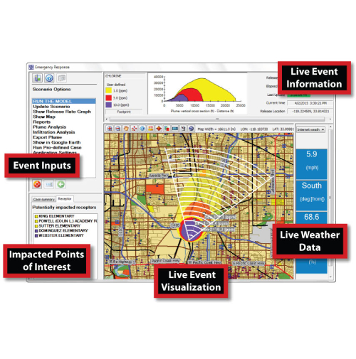
- Integrated approach to situational awareness: Utilizing current and historical data from gas monitoring sensors and meteorological inputs, the program calculates change as it occurs. All relevant history is used to provide snapshot reports and rapid visualizations that show clearly what has occurred, what is occurring and what may occur.
- Wide array of models (Available with Plume Response Add-on): SAFER Remote Responder includes an array of standard models covering fire and explosion, multi-component evaporation, building infiltration and exfiltration, tank and pipe, dispersion, complex terrain, and particulate and specialized chemicals like HF and TiCl4. These models have been developed with the help of more than 30 years experience solving fixed facility loss of containment events.
- Flexible and reliable weather data collection: A big part of effective response is getting good weather and gas monitoring data. Remote Responder does this automatically, helping select Internet weather stations or a local first responder weather station as well as wireless gas monitoring data. We use the best data available to solve the problem.
- Release Rate Calculations (Available with Advanced Back Calculation Add-on): SAFER's patented Advanced Back Calculation (ABC) application was developed to offer the most sophisticated solution available for release rate estimation from plume modeling and plume measurement.
- Simple one screen visualizations make the application easy to use and understand: Remote Responder was designed to be easy to use. It simplifies results by displaying all of the pertinent information on one screen. This makes seeing what is actually happening easy.
- Google Earth/Google Maps support: Remote Responder exports impact assessments allowing expanded analysis of the event which can be shared via email or through a live network connection.
- Source Area Locator (Available with Advanced Back Calculation Add-on): Understanding where an emission is coming from at 2am one dark morning might be very useful. This application helps you locate the source of an odor or hazardous materials emission location.
- Combustion Analysis Modeling (Available with Combustion Analysis Model Add-on): The newest development from SAFER®, this model analyzes any chemical fire, transitioning seamlessly from analyzing a toxic impact to a product of combustion, and determines downwind dispersion of combustion products, airborne particles, unburnt hazardous materials and soot deposition. The Combustion Analysis Model (CAM) supports particulate monitoring activities by providing the information necessary to accurately place monitors for gathering samples.
- A variety of reports documenting all stages of the event: A variety of graphical, text, and HTML reports include historical archiving for documenting the event, post-event analysis and claim validation. The program also saves every input and this allows a complete rerun of the event at any time using all of the original data collected.
Features and Benefits:
The Best Industry And Company Services
Add A Review